 Map posters & route art

Turn a place into a map print, a GPS-art route, a fair meeting point or a true-size map.
Cartograph turns your own OpenStreetMap extract into a print-ready city map poster (SVG, vector PDF, PNG), snaps a heart, star or self-drawn shape to its streets as a GPS-art route with GPX export, finds the fairest meeting point for up to twelve people, and moves countries across a Mercator world map to show their true size. Everything runs in your browser: no map, tile or routing server is contacted, and the OpenStreetMap attribution is on every export.
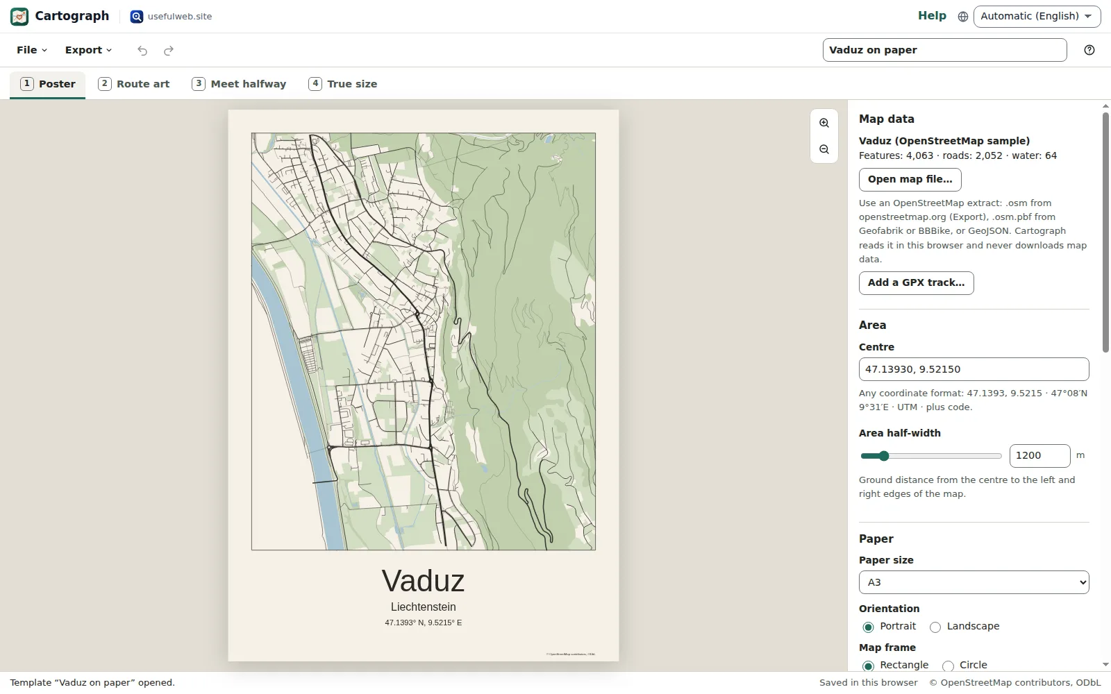
Screenshots
- A city map poster with its style panel
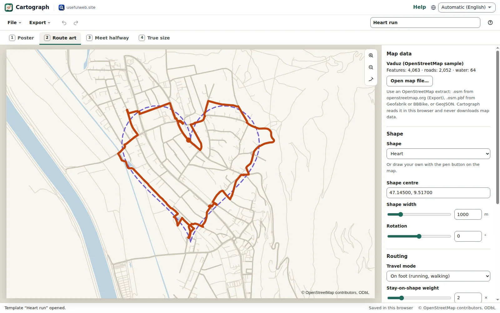 GPS-art route snapped to the streets
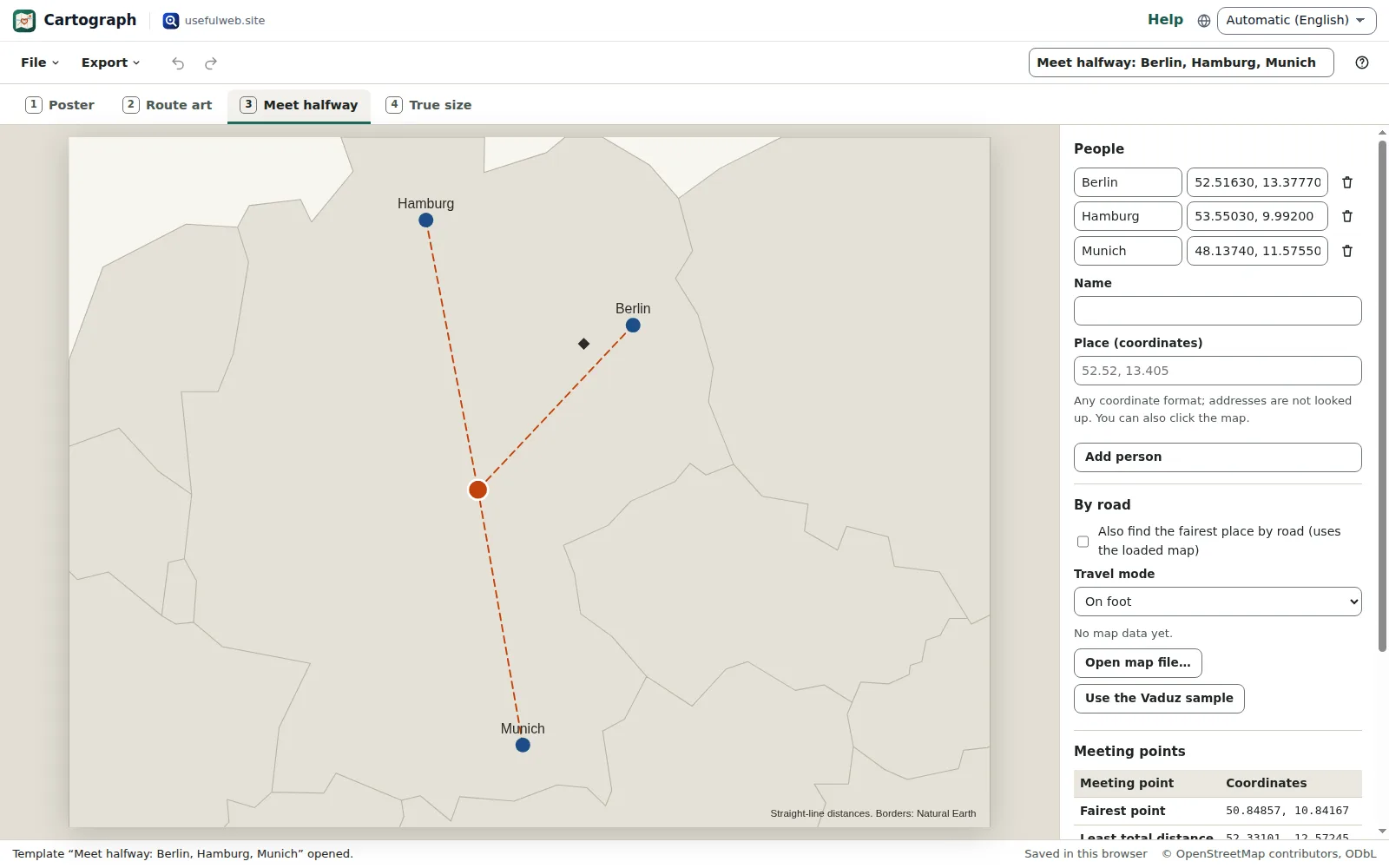 Fairest meeting point for three people
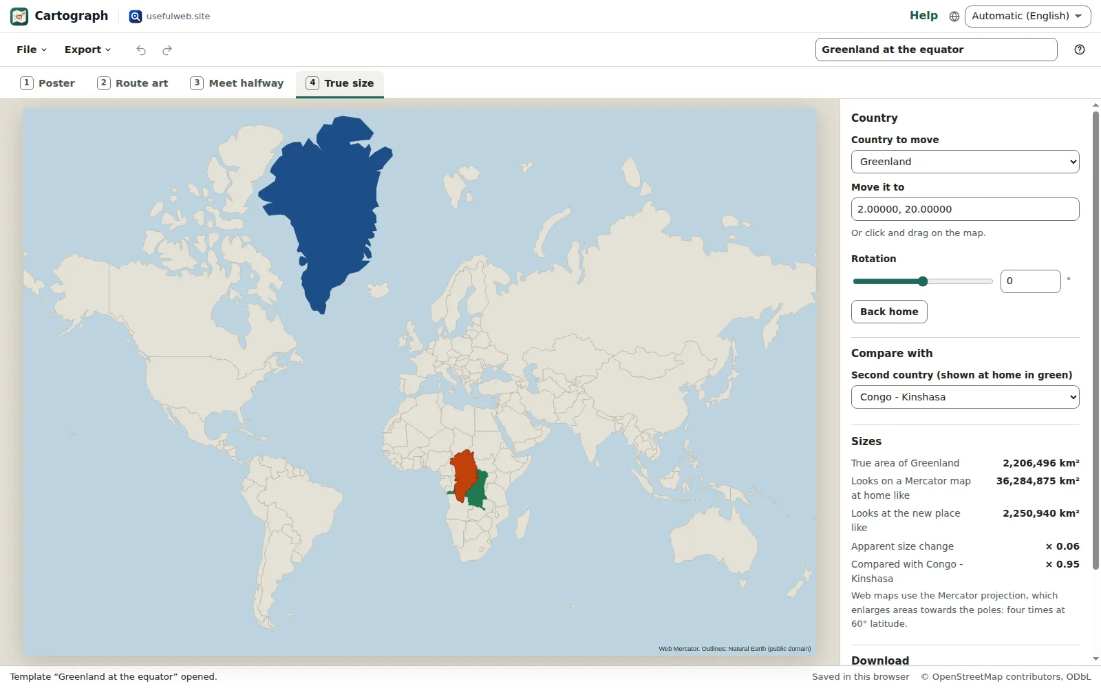 True size: Greenland at the equator
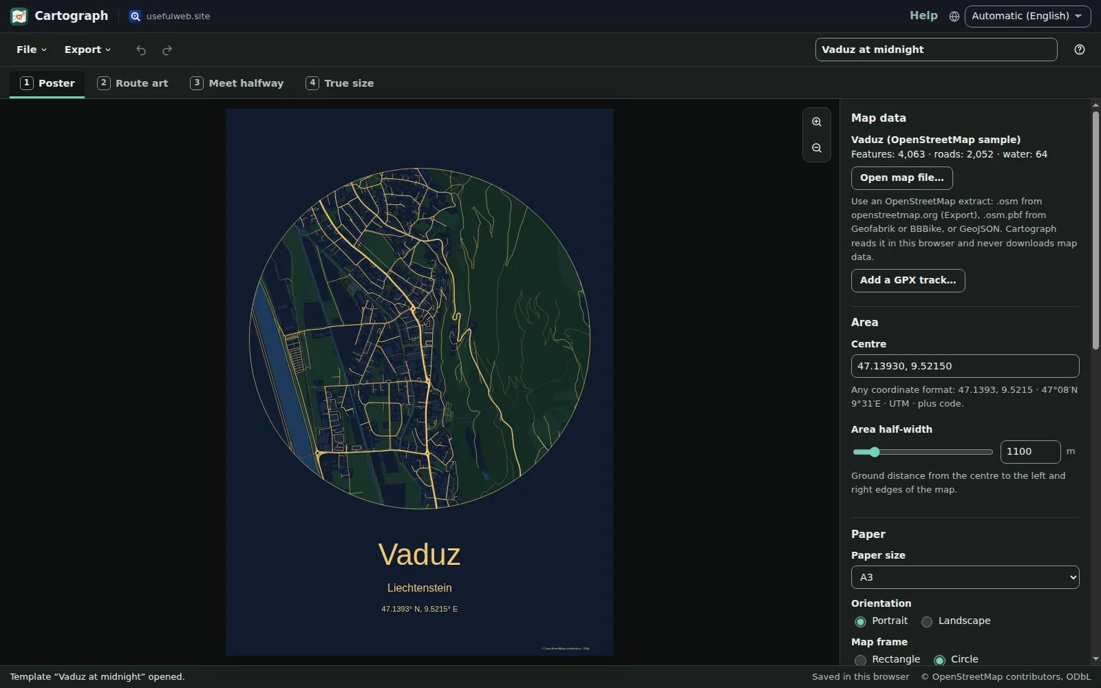 Round Midnight poster in the dark theme
Features
City map posters
Roads by class, paths, railways, rivers, lakes, parks, woods and optional buildings, framed as a rectangle or circle with title, subtitle and coordinates.
Six original styles
Paper, Midnight, Blueprint, Terracotta, Mono and Forest — on A4 to A2, 30 × 40, 50 × 70 cm, US Letter or a 30 × 30 cm square, portrait or landscape.
Your own OpenStreetMap data
Open .osm XML, .osm.pbf or GeoJSON extracts from your own export, Geofabrik or BBBike. Cartograph reads them locally and never downloads map data itself.
Print files
True-size SVG, vector PDF with embedded fonts for Arabic, Cyrillic, Greek and Devanagari titles, and PNG at 150 or 300 dpi.
GPS-art routes
Place a heart, star, circle, square, triangle, arrow or zigzag, and Cartograph snaps it to the streets with its own shortest-path routing.
Draw your own shape
Sketch any outline with the mouse, a pen or a finger, then move, scale and rotate it until the streets fit.
GPX for your watch
Download the route as GPX for running and cycling apps, with its length, how closely it follows the shape and the gaps it had to leave.
Meet halfway
The geodesic midpoint, the fairest point (nobody travels further than needed) and the least total distance for 2–12 people, in any coordinate format.
Meeting places by road
With a map loaded, Cartograph also finds the fairest meeting place along the walkable or rideable roads.
True size of countries
Drag a country across a Mercator world map: its true shape stays, and Cartograph shows how big it really is and how big it looks.
Private and offline
Your extracts, routes and meeting places stay in this browser. Share links leave out your map file and everyone’s places.
Projects, undo and share links
Autosave with recent projects, undo and redo, project files with the map included, share links and optional Google Drive saving.
Keyboard and screen readers
Arrow keys move the poster centre or the shape, plus and minus zoom, number keys switch tabs; every control is labelled, and single-key shortcuts can be switched off.
API and MCP tools
Map poster, route art, meet halfway and true size are also usefulweb tools with a JSON API and MCP, using the same engine as the app.


Templates
Start from a ready-made project and change it to fit.
Vaduz on paper
A cream A3 poster of Vaduz with roads, paths, the Rhine, parks and woods from the built-in OpenStreetMap sample.
Vaduz at midnight
A round poster in gold on navy with every building drawn.
Vaduz blueprint
A landscape A3 poster in white lines on blueprint blue, without footpaths.
Heart run
A one-kilometre heart snapped to the walkable streets of Vaduz, ready as GPX.
Star ride
A five-pointed star for a bike ride that respects one-way streets.
Meet halfway: Berlin, Hamburg, Munich
The fairest meeting point and the least total distance for friends in three German cities.
Greenland at the equator
Greenland moved to Central Africa next to DR Congo: much smaller than the Mercator map suggests.
Brazil over Europe
Brazil laid over Central Europe at its true size.
Built-in tools
Cartograph uses these tools. Each one also has its own page and works on its own, in the browser, through the JSON API and through MCP.
- Cartograph Map Poster (SVG + PDF from OpenStreetMap) Cartograph engineTurn an OpenStreetMap extract into a print-ready city map poster as SVG and vector PDF.
- Cartograph GPS Art Route Designer (shape → roads → GPX) Cartograph engineSnap a heart, star or other shape to the streets of your OSM extract and get a GPX route.
- Cartograph Meet Halfway (fair meeting point for 2–12 people) Cartograph engineFind the fairest meeting point for 2–12 people: geodesic midpoint, minimax and least total distance.
- Cartograph True Size of Countries (Mercator comparer) Cartograph engineMove a country to another latitude and see its true size against the Mercator map.
For AI agents
Cartograph runs on a deterministic engine. The same functions are available as tools with a JSON API and MCP, so scripts and AI agents get exactly the results the app shows.
- Cartograph Map Poster (SVG + PDF from OpenStreetMap) – Turn an OpenStreetMap extract into a print-ready city map poster as SVG and vector PDF.
Tool page ·POST https://cartograph.usefulweb.app/api/v1/tools/cartograph-map-poster/calculate· MCPcartograph_map_poster - Cartograph GPS Art Route Designer (shape → roads → GPX) – Snap a heart, star or other shape to the streets of your OSM extract and get a GPX route.
Tool page ·POST https://cartograph.usefulweb.app/api/v1/tools/cartograph-route-art/calculate· MCPcartograph_route_art - Cartograph Meet Halfway (fair meeting point for 2–12 people) – Find the fairest meeting point for 2–12 people: geodesic midpoint, minimax and least total distance.
Tool page ·POST https://cartograph.usefulweb.app/api/v1/tools/cartograph-meet-halfway/calculate· MCPcartograph_meet_halfway - Cartograph True Size of Countries (Mercator comparer) – Move a country to another latitude and see its true size against the Mercator map.
Tool page ·POST https://cartograph.usefulweb.app/api/v1/tools/cartograph-true-size/calculate· MCPcartograph_true_size
- MCP endpoint (Streamable HTTP):
https://cartograph.usefulweb.app/mcp - Project file format (JSON Schema): https://cartograph.usefulweb.app/project.schema.json
- OpenAPI description: /openapi.json · llms.txt · API & MCP
Build a project through the API, then open it in the app with a link to https://cartograph.usefulweb.app/app#project=<base64url JSON>.
Import & export
Import
- OpenStreetMap XML (.osm)
- OpenStreetMap PBF (.osm.pbf, zlib)
- GeoJSON with OSM tags
- GPX track (poster overlay)
- Cartograph project (.cartograph.json)
- Share link (#project=)
Export
- Poster SVG (true size)
- Poster PDF (vector)
- Poster PNG (150 or 300 dpi)
- Route GPX
- Route and meeting points as GeoJSON
- True-size map SVG and moved outline GeoJSON
- Cartograph project (.cartograph.json)
- Share link
Keyboard shortcuts
| Keys | Action |
|---|---|
| 1 … 4 | Switch to Poster, Route art, Meet halfway or True size |
| Arrow keys | Move the poster centre, the shape or the moved country (Shift: larger steps) |
| + / − | Show a smaller or larger area (poster), make the shape larger or smaller (route art) |
| [ / ] | Rotate the shape or the moved country |
| Enter | Snap the shape to the roads (route art) |
| Ctrl + Z | Undo |
| Ctrl + Shift + Z | Redo |
| Ctrl + S | Save project file |
| Ctrl + O | Open project file |
| ? | Show keyboard shortcuts (single-key shortcuts can be switched off there) |
Frequently asked questions
Where does the map data come from?
From an OpenStreetMap extract you provide: an .osm file exported from openstreetmap.org (Export → a small area), an .osm.pbf download from Geofabrik or BBBike, or GeoJSON with OSM tags. The built-in Vaduz sample is a small OpenStreetMap excerpt. Cartograph never calls Overpass, a tile server or a routing service.
May I print and sell my posters?
OpenStreetMap data is licensed under the ODbL: you may print, give away and sell posters as long as the attribution “© OpenStreetMap contributors, ODbL” stays on them — Cartograph prints it on every export. The design choices are yours; the Cartograph styles are original and free to use.
How large an extract can I open?
City and county extracts work well. Cartograph reads up to about 8 million nodes; for a country-size .osm.pbf, cut out your area first (for example with osmium extract) so the browser stays fast.
How does GPS art routing work without a routing service?
Cartograph builds the road graph from your extract, samples the shape into waypoints, snaps each one to the nearest street and joins them with its own A* shortest paths that prefer streets close to the drawing. It reports how much of the shape the route follows within 25 m.
Is the meeting point based on travel time?
No. The midpoint, fairest point and least total distance use straight-line (geodesic) distances. With a map loaded you can add the fairest meeting place along walkable or rideable roads; traffic, public transport and travel times are not modelled.
Why does Greenland look so big on most maps?
Web maps use the Mercator projection, which enlarges areas by sec² of the latitude — four times at 60°. Cartograph moves the true outline and shows both the true area and how big it looks on the Mercator map.
What do share links contain?
Only the settings: poster style and area, route shape and place, the true-size choice and the name of the built-in sample. Your own map file and the meeting group’s places are never put into a link.
Can I use non-Latin titles?
Yes. Titles in Latin, Greek, Cyrillic, Arabic and Devanagari scripts are embedded as Noto font subsets in the PDF. Chinese, Japanese and Korean titles appear in the SVG and PNG, but not yet in the PDF.
Limitations
What Cartograph does not do (yet):
- Cartograph does not search places or download map data: you need an OpenStreetMap extract of your area (only the Vaduz sample is built in).
- Posters draw roads, paths, railways, water, green areas and buildings, but no street names, labels, contour lines or hill shading; coastlines are drawn as lines, so the sea is not filled.
- GPS-art routes depend on the streets in the extract; access tags are taken as mapped, and closures, private grounds and safety are not known. Always check a route on site.
- Meeting points use straight-line distances; the road variant uses distance along roads, not travel time, traffic or public transport.
- True-size outlines are Natural Earth 1:110m: small countries and islands are missing, and coastlines are generalised.
- PDF titles in Chinese, Japanese or Korean are not embedded yet (use SVG or PNG for those).
- Large extracts (hundreds of thousands of features) make the poster preview slower on phones.
Tutorials
Learn Cartograph step by step.
- Your first city map posterOpen the Vaduz sample, choose a paper, a colour style and the layers, set the title and download a print-ready PDF poster from Cartograph.Beginner 6 min
- Use your own OpenStreetMap dataDownload an OpenStreetMap extract of your town (.osm, .osm.pbf or GeoJSON), open it in Cartograph, keep the right area and add a GPX track to your poster.Beginner 7 min
- GPS art routes on real streetsPlace a heart or a star on the map, let Cartograph snap it to walkable or rideable streets with its own routing, read the quality figures and download the route as GPX.Beginner 7 min
- Draw your own route shapeSketch any outline on the map with the mouse, a pen or a finger, place and scale it, and let Cartograph turn it into a GPS-art route along the streets.Intermediate 5 min
- Meet halfway – a fair point for everyoneEnter two to twelve places in any coordinate format and compare the geodesic midpoint, the fairest point and the least total distance, optionally along the roads of your map.Beginner 6 min
- The true size of countriesMove a country across a Mercator world map with its real shape and see how big it really is, how big it looks at home and how it compares with another country.Beginner 5 min
- Export, print, share and automatePrint Cartograph posters at true size, save and share projects, hand files to other premium apps, and create posters, routes and comparisons through the JSON API and MCP.Intermediate 6 min
Ready to try it?
Other premium apps
-

Twinworks
Factory digital twin & production simulation
Model a production line, simulate it and find the bottleneck — free, in your browser.
-

Lumina
Photo editor & image toolkit
Bring out what you saw. A free photo studio, right in your browser.
-

Soundscape Atlas
Sound map & ambience studio
Find real field recordings on a world map and mix them into calm, editable soundscapes.
-

RavingDesk
Paper trading & data workspace
Practise trading on paper and chart your data: orders, risk, datasets, analyses, reports.
-

Flipline
Drawing, storyboards & animation
A few drawings. A little life. Make a flipbook in your browser.
-

Ledgerly
Household finance & life-admin desk
Budgets, bills, subscriptions, loans, contracts and deadlines on one private desk.
-

Kerfwise
Cabinet & furniture CAD
Design cabinets and furniture, get cut lists, optimised sheet layouts, costs and drawings.
-

Chainscope
Web3 investigation desk
Investigate transactions, bridges, contracts, DAOs and wallets in one case file.
-

Ohmforge
Virtual electronics workbench
Draw a circuit, switch it on, and measure it with real-feeling bench instruments.
-

Hearth
Home & travel planner
Plan meals, chores, home care, moves, trips and good days for your household in one place.
-

ObscurIQ
OSINT case desk
Organize public-source research: cases, a research log, pivots and indicators.
-

Proofline
Math notebook
Solve, graph, test and visualise in one notebook — with data, findings and a report.
-

Opsdeck
Developer & ops workbench
One deck for CI failures, cron, traces, k8s events, API diffs, query plans and Terraform.
-

Threadsmith
Embroidery digitizing studio
Draw or import artwork, turn it into stitches, export DST, PES, JEF or EXP files.
-

Renderloom
3D scene & material studio
Shape a scene. Find its light. Keep every idea editable.
-

Reelcraft
Audio, video & image batch studio
Audio, video & image batch studio: cut, convert, compress, subtitle, reframe
-

Kinetica
Robot motion studio
Simulate robot arms in your browser: kinematics, trajectories, collisions, program export.
-

Paperwell
Document studio: PDFs, OCR, redaction, forms & contract reading
Your paperwork in one dossier: PDF tools, OCR, redaction, forms and contract reading.
-

Pageboard
Website inspiration boards
Collect website references, sort them with tags and arrange them on a moodboard.
-

Fieldday
Sports club & training organiser
Fixtures, brackets, ratings and training plans for your club — in one workspace.
-

Agentlab
AI-agent & LLM workbench
Test an AI agent before release: permissions, traces, costs, citations and output checks.
-

Tonegrid
Tone matrix & beat sequencer
Light up squares to build melodies, beats and acid bass, then arrange them into songs.
-

Keysmith
Crypto & secrets lab
Audit certificates, keys, TLS and passwords in one lab; secrets stay on your device.
-

Signalhouse
Website & internet infrastructure inspector
Inspect DNS, TLS, mail, CDN and routing of all your domains — and see what changed.
-

Provenance
Software supply-chain security desk
SBOMs, CVEs, containers and licences in one risk register — free, in your browser.
-

Panelcraft
Comic books & figure references
Shape a page. Arrange a book. Give your story a voice.
-

Bundlekeep
Local project backup
Back up projects from every usefulweb app into one file, check it and restore any part.
-

Focus Room
Ambience player & focus timer
A calm room for your screen: ambience playlists, gentle effects, slow visuals and a timer.
-

Printshop
Printables studio
QR codes, calendars, labels, graph paper and posters — print-perfect PDFs in seconds.
-

Skyfold
Sky & space atlas
See the sky of any place and moment, plan eclipses and satellite passes, print star maps.